


| Source: Date: Updated: |
TheBahamasInvestor.com
Wednesday, September 6, 2017 Wednesday, September 6, 2017 |
The southeast Bahamas and the Turks and Caicos Islands have been placed under a Hurricane Watch and can feel impact of Hurricane Irma within 48 hours.
The Bahamas Department of Meteorology issued Alert #3 September 5, 2017 at 12 noon.
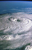
The potentially catastrophic Category 5 Hurricane Irma is moving toward the Leeward Islands.
A Hurricane Watch is now in effect for the southeast Bahamas and the Turks and Caicos Islands. This includes the islands of Inagua, Acklins and Crooked Island, Mayaguana, Long Cay, Samana Cay, Ragged Island and the Turks and Caicos Islands.
A Hurricane Watch means that hurricane conditions could affect the Southeast Bahamas and the Turks and Caicos Islands within 48 hours.
Hurricane Irma is moving toward the west at about 14 mph and this general motion is expected to continue, followed by a turn toward the west-northwest. On the forecast track, the extremely dangerous core of Irma is forecast to move over portions of the Leeward Islands early Wednesday.
Maximum sustained winds are near 180 miles per hour with higher gusts. Irma is an extremely dangerous category five hurricane on the Saffir-Simpson Hurricane Wind Scale. Some fluctuations in intensity are likely during the next day or two, but Irma is forecast to remain a powerful category four or five hurricane during the next couple of days.
Hurricane force winds extend outward up to 60 miles from the centre and tropical storm force winds extend outward up to 160 miles from the centre.
Residents in the Southeast Bahamas and the Turks and Caicos Islands should continue to make preparations as they can begin to experience the effects of Hurricane Irma by Thursday afternoon.
Residents throughout the remainder of The Bahamas are advised to seriously begin making preparation for Hurricane Irma should the need arise.
Extensive flooding can be expected as Irma is forecast to produce up to 6 inches of rainfall.
Storm surge up to 10 feet above normal tide can be expected.
Small craft operators throughout The Bahamas and the Turks and Caicos Islands should begin to seek safe harbour for their vessels.

